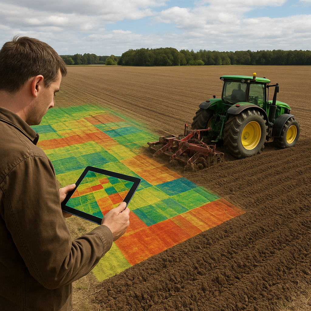
Precision agriculture has transformed modern farming by harnessing cutting-edge technology to boost productivity and resource efficiency. Among these innovations, Satellite imagery plays a pivotal role in optimizing plowing operations. By analyzing high-resolution images, farmers can identify soil variability, moisture levels and field anomalies, ultimately improving plowing precision and reducing fuel consumption. This guide explores practical steps to integrate satellite data into your plowing workflow and offers expert tips for harnessing the full potential of remote sensing for enhanced field performance.
Understanding Satellite Imagery for Agriculture
Before incorporating satellite data into plowing routines, it is essential to grasp the fundamentals of how imagery works. Satellites capture reflected light and other electromagnetic signals from the Earth’s surface. Each pixel in an image represents a small ground area, conveying information about vegetation health, soil moisture and topography. When processed properly, these images enable informed decisions about when, where and how to plow.
Key Data Types and Their Applications
- NDVI (Normalized Difference Vegetation Index): Reflects plant vigor and can highlight areas of weak crop residues or organic matter.
- Soil Moisture Maps: Derived from radar or optical sensors, revealing wet and dry zones.
- Topographic Data: Elevation models help detect slopes and potential erosion risks.
- Thermal Imaging: Indicates heat retention, pointing to compacted or waterlogged patches.
Major Satellite Platforms
Several spaceborne systems offer agricultural data at varying resolutions:
- Landsat (30 m resolution, free access, 16-day revisit)
- Sentinel-2 (10–20 m resolution, 5-day revisit, free)
- Commercial Satellites (PlanetScope, WorldView; sub-meter resolution, subscription-based)
- Weather Satellites (NOAA, METEOSAT; broader coverage for climate monitoring)
Integrating Imagery into Plowing Strategies
To leverage remote sensing effectively, create a systematic Workflow that integrates data acquisition, processing and field execution. Follow these core steps:
1. Planning and Data Collection
- Define target fields and objectives: soil conditioning, residue mixing or weed control.
- Schedule image acquisition: select dates with minimal cloud cover and post-harvest conditions.
- Acquire historical datasets: compare multi-year imagery to detect recurring patterns.
2. Data Processing and Interpretation
- Preprocess images: apply atmospheric correction and georeferencing for accurate overlays.
- Calculate indices: NDVI for residue cover, bare soil index for exposed ground.
- Generate prescription maps: assign plowing intensity or depth zones based on imagery analysis.
3. Field Calibration
Ground-truthing ensures remote observations align with real conditions. Visit representative points to:
- Measure soil moisture with a probe.
- Assess residue thickness and distribution.
- Note unexpected obstacles like rocks or compacted strips.
- Adjust digital maps in a GIS platform before exporting to GPS-enabled tractors.
Advanced Techniques and Tools
Beyond basic imagery, advanced sensors and analytics can further refine your plowing approach. Integrating multiple technologies yields a comprehensive field overview.
Multispectral and Hyperspectral Analysis
Multispectral sensors capture several discrete bands (red, green, NIR) to produce indices like NDVI. Sensors on hyperspectral platforms, however, record dozens of contiguous bands, enabling detection of subtle soil composition variations and residue material differences. This detail can guide tillage depth adjustments to optimize mixing and breakdown.
Machine Learning for Field Segmentation
Train classification algorithms on labeled image samples—crop rows, bare soil, wet spots and compacted areas. The model then segments entire fields into zones requiring specific plow settings. Combining optical data with historical yield points enhances the algorithm’s predictive power for unseen seasons.
Drone Complementation
- Deploy drones to fill gaps in satellite coverage, especially during short weather windows.
- Capture ultra-high-resolution orthomosaics to verify satellite-derived zones.
- Use LiDAR-equipped drones to refine elevation models for erosion control planning.
Practical Tips for Field Implementation
Translating analytic insights into real-world plowing success demands careful execution. Keep these operational best practices in mind:
Equipment Setup and Calibration
- Ensure your tractor’s GPS receiver is configured for RTK or DGPS corrections to maintain centimeter-level Accuracy.
- Calibrate plow hydraulics and depth sensors daily, especially when transitioning between zones.
- Download prescription files in compatible formats (e.g., shapefile, ISOXML) prior to heading to the field.
On-the-Go Monitoring
Modern displays offer real-time overlay of prescription maps. Follow these guidelines:
- Highlight active plow zones with color-coded boundaries on the screen.
- Set audible alerts for zone transitions to prompt depth adjustments.
- Record actual depth and speed metrics for post-operation review.
Post-Plowing Analysis
After completing operations, revisit key points to verify results and collect data for continuous improvement:
- Use yield monitor outputs to correlate plowing patterns with subsequent crop performance and Yield variability.
- Compare pre- and post-plow NDVI or bare soil indices to assess residue incorporation effectiveness.
- Document lessons learned and refine your remote sensing Mapping approach for the next season.
Maximizing Long-Term Benefits
Consistent use of satellite imagery fosters a proactive management cycle: plan, execute, evaluate and adjust. Over multiple Years, this process uncovers trends—soil compaction hotspots, erosion-prone slopes and nutrient-deficient areas—allowing you to tailor tillage to field-specific needs rather than applying a one-size-fits-all approach. By integrating satellite data with on-site calibration and advanced analytics, your plowing operations will achieve unprecedented levels of Precision and sustainability.